The AequilibraE project#
Similarly to commercial packages, any AequilibraE project must have a certain structure and follow a certain set of guidelines in order for software to work correctly.
One of these requirements is that AequilibraE currently only supports one projection system for all its layers, which is the EPSG:4326 (WGS84). This limitation is planned to be lifted at some point, but it does not impact the result of any modeling procedure.
AequilibraE is built on the shoulder of much older and more established projects, such as SQLite, SpatiaLite and NumPy, as well as reasonably new industry standards such as the Open-Matrix format.
impressive performance, portability, self containment and open-source character of these pieces of software, along with their large user base and wide industry support make them solid options to be AequilibraE’s data backend.
Since working with Spatialite is not just a matter of a pip install, please refer to Dependencies. For QGIS users this is not a concern, while for Windows users this dependency is automatically handled under the hood, but the details are also discussed in the aforementioned dependencies section.
Project structure#
Since version 0.7, the AequilibraE project consists of a main folder, where a series of files and sub folders exist, and the current project organization is as follows:
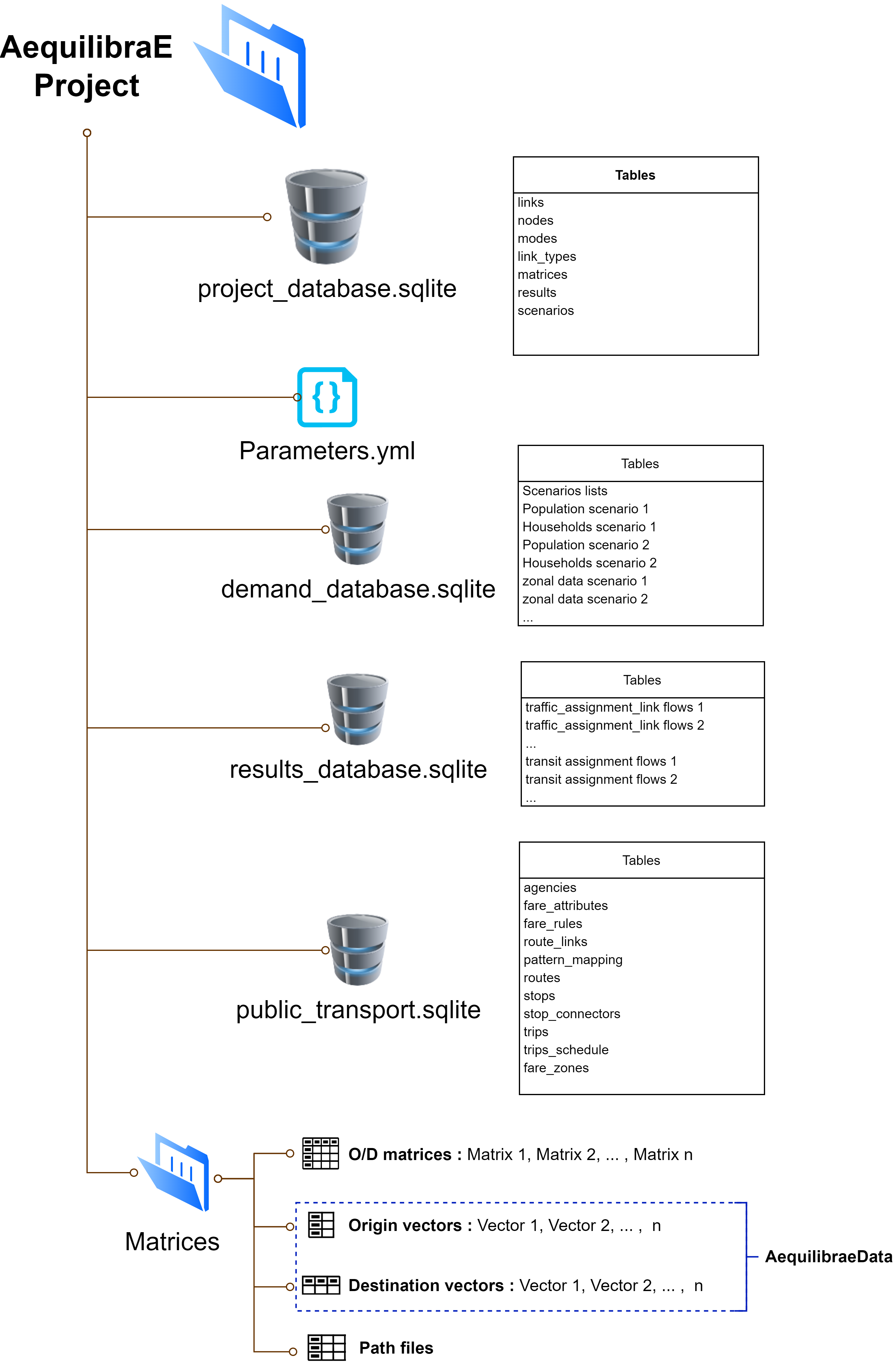
The main component of an AequilibraE model is the project_database.sqlite, where the network and zoning system are stored and maintained, as well as the documentation records of all matrices and procedure results stored in other folders and databases.
The second key component of any model is the parameters.yaml file, which holds the default values for a number of procedures (e.g. assignment convergence), as well as the specification for networks imported from Open-Street Maps and other general import-export parameters.
The third and last required component of an AequilibraE model is the Matrices folder, where all the matrices in binary format (in AequilibraE’s native AEM or OMX formats) should be placed. This folder can be empty, however, as no particular matrix is required to exist in an AequilibraE model.
The database that stores results in tabular format (e.g. link loads from traffic assignment), results_database.sqlite is created on-the-fly the first time a command to save a tabular result into the model is invoked, so the user does not need to worry about its existence until it is automatically created.
The demand_database.sqlite is envisioned to hold all the demand-related information, and it is not yet structured within the AequilibraE code, as there is no pre-defined demand model available for use with AequilibraE. This detabase is not created with the model, but we recommend using this concept on your demand models.
The public_transport.sqlite database holds a transportation route system for a model, and has been introduced in AequilibraE version 0.9. This database is also created on-the-fly when the user imports a GTFS source into an AequilibraE model, but there is still no support for manually or programmatically adding routes to a route system as of yet.
Package components: A conceptual view#
As all the components of an AequilibraE model based on open-source software and open-data standards, modeling with AequilibraE is a little different than modeling with commercial packages, as the user can read and manipulate model components outside the software modeling environments (Python and QGIS).
Thus, using/manipulating each one of an AequilibraE model components can be done in different ways depending on the tool you use for such.
It is then important to highlight that AequilibraE, as a software, is divided in three very distinctive layers. The first, which is responsible for tables consistent with each other (including links and nodes, modes and link_types), are embedded in the data layer in the form of geo-spatial database triggers. The second is the Python API, which provides all of AequilibraE’s core algorithms and data manipulation facilities. The third is the GUI implemented in QGIS, which provides a user-friendly interface to access the model, visualize results and run procedures.
These software layers are stacked and depend on each other, which means that any network editing done in SQLite, Python or QGIS will go through the SpatiaLite triggers, while any procedure such as traffic assignment done in QGIS is nothing more than an API call to the corresponding Python method.